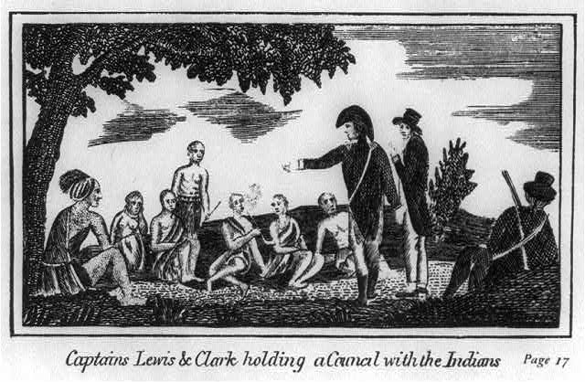
No two explorers are more firmly imprinted in the American consciousness than Meriwether Lewis and William Clark. Rivers, counties, towns, schools, and wildlife refuges in Oregon are named after them. Monuments honor them, hundreds of books have been written about them, and a formal organization, the Lewis and Clark Trail Association, is devoted to studying them. Lewis and Clark and their scientific expedition are central to Oregon and United States history, and their story helps explain the links between exploration and the formation of empire.
No American political figure is more central to westward expansion than Thomas Jefferson. He was an architect of American democracy, a linguist, a natural scientist, a philosopher-statesman, an inventor, and a “vicarious explorer.” Jefferson was first interested in the West immediately beyond the Appalachian Mountains, but by the 1780s he had expanded his view to include the entire Trans-Mississippi West. He developed a grand design to explore an interior Northwest Passage, following the Missouri and Columbia Rivers, that would link the Mississippi Valley to the Pacific Ocean. Early in his presidency, Jefferson wrote Meriwether Lewis’s commanding officer that he wanted a personal secretary who understood both the army and the “Western Country.” The president selected a fellow Virginian, the young military officer Meriwether Lewis.
From the moment Lewis arrived in Washington, D.C., Jefferson put him to work learning about the American West, its topography, river systems, climates, and Native peoples. Jefferson was familiar with Alexander MacKenzie’s 1793 trek across present-day Canada, and he was particularly concerned with MacKenzie’s recommendation that British fur-trading companies move quickly and decisively to gain control of the trade in the Columbia River country.
By the fall of 1802, Jefferson had directed Lewis to lead a scientific expedition to the Pacific. Many scholars argue that Jefferson’s grand design was probably fully matured by the time he was inaugurated as president in March 1801. Writer Bernard DeVoto, for example, concluded that sending the Lewis and Clark Expedition west was “an act of imperial policy.” Historian Stephen Ambrose painted Jefferson in even larger terms: “In an age of imperialism, he was the greatest empire builder of them all. His mind encompassed the continent.”
In February 1802, before the United States purchased the vast Louisiana territory from France, Jefferson asked Congress for appropriations for the expedition. While Lewis was awaiting Clark’s decision about joining him on the journey, Jefferson sent Lewis instructions: “The purpose of your mission is to explore the Missouri River, & such principal stream of it as, by its course and communication with the waters of the Pacific Ocean, whether the Columbia, Oregon, Colorado or any other river, may offer the most direct and practicable water communication across this Continent for the purposes of commerce.”
The Corps of Discovery successfully carried out Jefferson’s plan, traveling from St. Louis to the Pacific Ocean and back again, with the loss of only one life. The geographic and natural science findings, the ethnographic information, and the journals—the first version published in 1807—have served as primary sources for more than 150 years. The journals document that the captains were no different from their countrymen in stereotyping native people as uncivilized and savage, but they also commented favorably on Native technology and knowledge of flora and fauna.
Lewis and Clark were much more than disinterested scientists and geographers in their reporting about the Columbia River country. Like British sea captains James Cook and George Vancouver, the American officers provided their country with strategic information about the western reaches of the continent. They also concluded that Jefferson’s dream of a Northwest Passage was unattainable and warned against using the Columbia River as a commercial waterway because of its many falls and rapids.
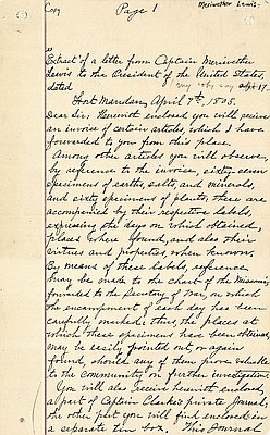
Nevertheless, Lewis urged Jefferson to establish fur-trading posts on the Columbia River to counter the designs of the “British N. West Company of Canada.” Establishing such posts, Lewis advised, would give the Americans advantage in controlling the trade on both the Columbia and Missouri Rivers.
The increasing activities of land-based fur trades in the opening decade of the nineteenth century marked the onset of accelerating change in the Pacific Northwest. Several individuals—referred to in the literature as clerks, factors, and traders—left journal accounts that shaped what would soon become standard representations of the Oregon Country. The writing of Ross Cox, Peter Skene Ogden, Alexander Ross, David Douglas, and David Thompson depicted the climate, topography, plants, and animals of the region, describing the Oregon Country for those who had not yet ventured west.
© William G. Robbins, 2002. Updated and revised by OE Staff, 2014.
