Perhaps the most important aspect of central Oregon geography is the isolation. To the visitor arriving on a night flight from Seattle, the seven communities of central Oregon are pools of light surrounded by a sea of darkness. To the west, the dark forests of the Cascade range extend one hundred miles to the Willamette Valley. To the north of Warm Springs and Madras, lower Deschutes County is sparsely populated for 150 miles to the Columbia Gorge. On the eastern side of Prineville, the lava plains and the forests of the Ochoco Mountains run east to the John Day and Malheur drainages. South of La Pine, the forests of the Klamath Divide stretch south to the Klamath Basin.
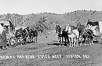
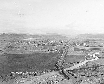
The physical thread that connects the communities of central Oregon is the Deschutes River and its tributaries. La Pine, the southernmost community, sits at the highest elevation in the north-flowing Deschutes system. It is located on grasslands near the confluence of the two major forks of the upper river. Further north, Bend straddles the river at a historic crossing. Redmond is on the east bank of the Deschutes north of Bend. Prineville, oldest of the central Oregon communities, is located on the Crooked River, the eastern tributary of the Deschutes. Sisters, to the west, is on Squaw Creek. Near Sisters is the Metolius River, the largest of the Deschutes’s western tributaries. Madras is located above the Deschutes near the Agency Plains. Warm Springs is on Shitike Creek, another major western tributary. A few miles north, down river, the Warm Springs River enters the Deschutes. Still further north, the small communities of Maupin and the Tygh Valley are located on the Deschutes and on White River, which drains the eastern slope of Mt. Hood.
The most important land form for central Oregon is the Cascade Range. This wall of mountains to the west forms a barrier that blocks the westerly winds that bring precipitation from the Pacific. The eastern slope of the Cascades from Mt. Hood south to the Klamath Divide creates the major watershed for the Deschutes. Fed by the Cascade snow fields, the Deschutes runs north to the Columbia through a semi-arid area known as the Deschutes Plateau. South of Grizzly Mountain, the plateau merges into the High Lava Plains. This land form continues south to the Klamath Divide. East of the Deschutes Valley is the Blue Mountains country, including the Trout Creek and Crooked River drainages and the Ochoco Mountains.
Within this complicated landscape, barriers abound. The Deschutes and its tributaries run through canyons incised into the surrounding plateau. Lt. Henry Larcom Abbot noted in 1853 that “the streams [are] sunk about 1000 feet below the level of the land & they [are] bordered by banks almost vertical.” There are few natural crossing points on the river, and at these places the Native American trails and emigrants’ roads converged. Mountain barriers running perpendicular to the Cascades hindered north-south travel through the country. These include the Mutton Mountains, the Grey Butte/Smith Rock complex, the Paulinas, and Walker Rim. Finally, there are the arid expanses of exposed rock and scrubby sage. Among these are the High Desert, the Lower Desert, the lava beds, Sidwalter Flats, the Devil’s Garden, and other badlands too numerous to mention. A quirk of the deep basalt that underlies the country is its ability to soak up the sparse precipitation. There is almost no surface water in central Oregon except in the major creeks and the branches of the Deschutes.
The climate is best described as cool and dry. In Lt. Henry Abbot’s 1853 correspondence he noted, “we have had some pretty cold weather for summer, as the thermometer has indicated only 15 above zero several times at sunrise.” The altitude ranges from 4,500 feet at the Klamath Divide to 1,000 on the Deschutes Plateau. The high altitude accounts for some of the coldness, but Lt. Abbot’s experience of fifteen degrees on summer mornings suggests that other forces are also at work. Precipitation varies from fourteen inches to less than ten inches. The standard explanation for the climate is that central Oregon lies in the “rain shadow” of the Cascades. This means that warm moist marine air from the Pacific cannot rise over the mountains, so it loses its moisture on the west slope clotting the hills and the passes with snow. While Chemult averages only sixteen inches of snow each year, Crater Lake, twenty miles to the west of Chemult, averages 540 inches.
With a cold and semi-arid climate and shallow, rocky soils, central Oregon has a limited inventory of indigenous plants. On the Cascade slopes, ponderosa pine forests prevail, ranging down to about 3,500 feet. They also extend to the east of the Deschutes in the Blue Mountains, the Paulinas, and Walker Rim. Below 3,500 feet, the juniper forest takes over. Where the juniper cannot grow, sage, bitterbrush, and grasses predominate. Exogenous plants include rabbitbrush, cheatgrass, mullein, and various weeds. Dry farmers on the plateau, lonesome for a bit of green, planted Lombardy poplars for shade, windbreak, or perhaps as a “matrimony vine.” Some of the poplars have outlasted the settlers.
© Ward Tonsfeldt and Paul G. Claeyssens, 2004. Updated and revised by OHP staff, 2014