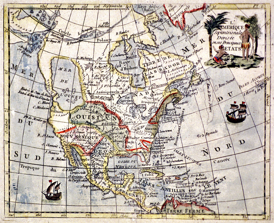
The full title for this French map is L’Amérique Septentrionale Divisée en ses Principaux Etats and translates as “North America divided into its principal states.” Although the name of the cartographer and the exact date of the map’s publication are unknown, its similarity to the 1752 map by Frenchman Joseph-Nicolas de l’Isle suggests that it was produced in the 1750s.
This colorful map illustrates the state of European knowledge about North American geography in the mid-eighteenth century. Eastern Canada, the Atlantic seaboard, the Great Lakes, the vast territory of Louisiana, and the Spanish possessions are relatively well represented. However, the northwestern regions are wildly inaccurate, demonstrating a reliance on imagination rather than factual information. Present-day Oregon and Washington correspond to Francis Drake’s “New Albion,” with a gigantic Mer de l’ouest (western sea) located in the plateau and Rocky Mountains regions. Farther north, a series of fictive rivers and lakes comprise the mythical Northwest Passage, then referred to as the “Strait of Anian” by the Spanish.
From the sixteenth century through the early eighteenth century, travel narratives by Europeans claiming to have explored the Northwest Coast shaped the perceptions of European map makers. The most well-known published accounts were those of Francis Drake, Juan de Fuca, and Bartholomew de Fonte. Drake, an English privateer, completed the second circumnavigation of the world in the years 1678-1680. A travel log kept by Drake’s chaplain, Francis Fletcher, suggests that his ship ventured along the Northwest Coast in the summer of 1679, possibly reaching as far north as the Strait of Juan de Fuca and Vancouver Island. Drake subsequently found harbor down the coast in Oregon or California and claimed the region for Queen Elizabeth, naming it “New Albion” in honor of Great Britain.
Although the travel accounts of Juan de Fuca (1625) and Bartholomew de Fonte (1708) are now seen as more fiction than fact, they had a significant impact on European cartography. Juan de Fuca, a Greek mariner supposedly sailing under a Spanish flag in 1592, claimed to have discovered the mythical Strait of Anian leading to the Atlantic Ocean. The Entrée de Juan de Fuca remained on European maps into the eighteenth century and was later adopted as the official name for the entrance to Puget Sound. De Fonte’s narrative recounted a Spanish expedition to the Northwest Coast in 1640 which entered a strait leading to a large inland sea. Here the party supposedly met a Boston ship traveling eastward through the mythical Northwest Passage. These imaginative ideas about the geography of the Northwest Coast were not laid to rest until the latter decades of the eighteenth century, after European and American mariners had accurately charted the region.
Further Reading:
Carey, Charles. “Some Early Maps and Myths.” Oregon Historical Quarterly 30, 1929: 14–32.
Williams, Glyn. Voyages of Delusion: The Quest for the Northwest Passage. New Haven, Conn., 2003.
Hayes, Derek. Historical Atlas of the North Pacific Ocean: Maps of Discovery and Scientific Exploration, 1500 – 2000. London, UK. 2001.
Written by Melinda Jette, © Oregon Historical Society, 2003