- Catalog No. —
- OrHi 36867
- Date —
- circa 1855
- Era —
- 1846-1880 (Treaties, Civil War, and Immigration)
- Themes —
- Environment and Natural Resources, Transportation and Communication
- Credits —
- Oregon Historical Society
- Regions —
- Cascades Columbia River
- Author —
- M.M Hazeltine
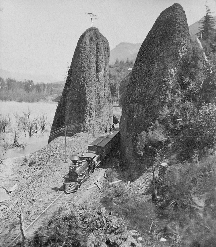
Train Passing through The Needles, c. 1885
This photograph, taken about 1885, shows a freight train of the Oregon Railway & Navigation Company along the south shore of the Columbia River several miles east of Troutdale.
Oregon’s incorporation into the industrial life of the United States began in earnest in the 1880s with the completion of several railroad construction projects that linked the state with California and the Upper Midwest. One of these lines was that of the Oregon Railway & Navigation Company (OR&N), which became a portion of the Union Pacific Railroad system. The OR&N east from Portland connected at Huntington with the Oregon Short Line, linking directly to Salt Lake City, Denver, Omaha, and Chicago. The tracks through the Columbia River Gorge were opened to traffic in 1882, and the through line to the east via Huntington commenced operations November 11, 1884.
The Columbia River Gorge presented tremendous engineering obstacles for a water-level railroad grade. Among these were fluctuating river levels, sand dunes at the eastern end, extensive marshlands, and immense basalt ridges that required tunneling, such as at Oneonta Creek. Many of the prominent geologic features of the Gorge carry names that refer to other places and characteristics: St. Peter’s Dome, Cape Horn (there are two of these), The Dalles. Two basalt pillars, located near the similar feature known as Rooster Rock, have been called The Needles, and also the Pillars of Hercules. The OR&N tracks threaded between the pillars provide a juxtaposition of dramatic natural scenery with modern industrial might. Published pictures and postcards of The Needles posed with a passing train were popular for many years.
The Pillars of Hercules still stand today. The railroad tracks have been rerouted around them, but Interstate 84 passes within a few hundred feet. Few travelers notice them, shrouded by trees and no longer visible as icons of the pre-industrial Oregon landscape.
Further Reading:
Toedtemeier, Terry N. “Focusing on the Columbia Gorge: Photography, Geology, and the Pioneer West.” Oregon Historical Quarterly 105, 2004: 422-437.
Written by Richard Engeman, © Oregon Historical Society, 2005.