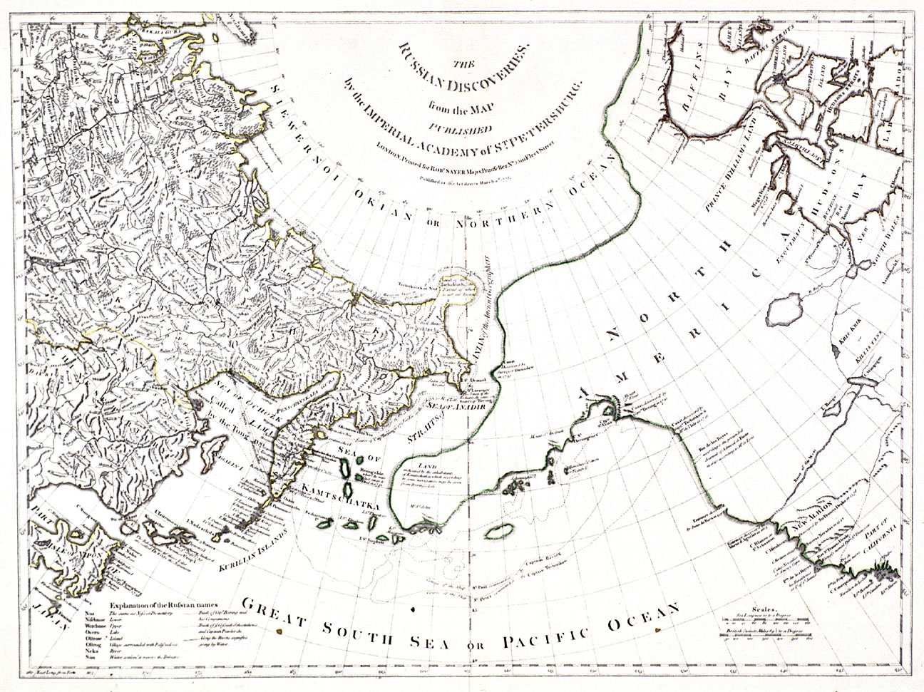
This map is an English reproduction of the influential 1758 map published by Gerhard Friedrich Müller. The German-born Müller, a professor at the Russian Academy of Sciences in St. Petersburg, included it in his account of the Russian exploratory expeditions to Siberia, Kamchatka, and Alaska undertaken in the first half of the eighteenth century. The first English translation appeared in 1761.
Like their counterparts in Western Europe, Russian authorities wanted to ascertain the geographic relationship between Asia and North America. For this reason, in 1725 the Russian Tsar Peter the Great dispatched an exploratory expedition led by Vitas Jonassen Bering, a Dane in the service of the Russian navy. During the First Kamchatka Expedition (1725–1730) Bering discovered the strait which bears his name, thereby demonstrating that North America and Asia were indeed separated by water. However, Bering did not sight the American landmass due to poor weather. The Second Kamchatka Expedition (1733–1743), was a much more extensive undertaking, involving some 10,000 men, including Gerhard Müller, who remained with the expedition until 1738. As charted in this map, the two ships captained by Vitas Bering and Alexsei Chirikov explored the Alaskan coast. Bering ventured as far south as Kayak Island, and Chirikov sighted the coastline near present-day Sitka, but did not make landfall. Their return journeys to Kamchatcha were harrowing: Chirikov’s crew returned safely but only a handful of Bering’s group made it home alive. Bering died with most of his crew on present-day Bering Island, located southeast of the Kamchatka Penninsula.
The Müller map represented improvements over the fanciful work of earlier cartographers, particularly with regard to the connection between North America and Asia, and the rudimentary representation of the Alaskan coastline. However, the detailed section on Siberia lies in stark contrast to the vast, empty regions of the Northwest coast. Like his predecessors, Müller reproduced the “Entrance of San Juan de Fuca,” Bartholomew de Fonte’s Rio de los Reyes (River of the Kings), and Francis Drake’s “New Albion.” Rather than a western sea linking the coast with the continental interior as seen in earlier European maps, here a “River of the West” runs from the supposed Entrance of Martin d’Aguilar to Lake Winnipeg (located in present-day Manitoba, Canada).
Related Historical References:
Black, Joseph Laurence. Gerhard Friedrich Müller and the Imperial Russian Academy. Montreal, Canada, 1986.
Fisher, Raymond Henry. Bering’s Voyages: Whither and Why. Seattle, Wash., 1977.
Kushnarev, E. G. Bering’s Search for the Strait: The First Kamchatka Expedition, 1725 – 1730. Translated by E. A. P. Crownhart-Vaughan. Portland, Oreg., 1990.
Hayes, Derek. Historical Atlas of the North Pacific Ocean: Maps of Discovery and Scientific Exploration, 1500 – 2000. London, England, 2001.
Written by Melinda Jette, © Oregon Historifcal Society, 2003.