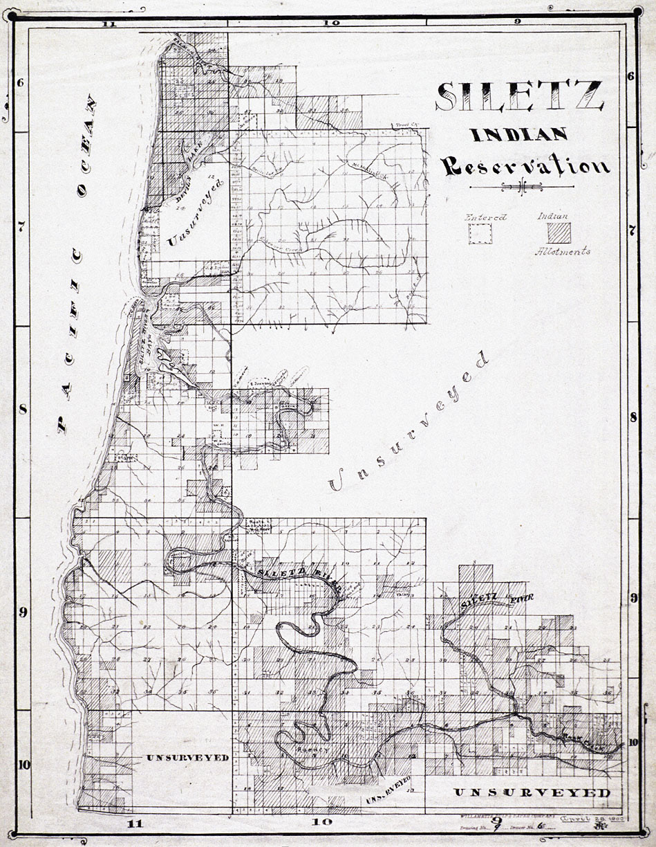
This map, produced by the Willamette Pulp and Paper Company, shows what remained of the Siletz Reservation in 1900. Each of the small squares on the map represents a 160-acre quarter-section. The darkened quarter-sections in this map represent Indian allotments, while the light-colored quarter-sections marked with dashes on the border represent non-Indian land claims.
The federal government established the Siletz Reservation and the adjacent Grand Ronde Reservation in 1856. Shortly thereafter, several thousand Indians from the coast and the interior valleys of western Oregon were forcibly removed to the two reservations.
Allotment, which began on the Siletz in 1887, involved the survey of the reservation land base and its division into a rationalized grid of townships, sections, and quarter-sections. The land was then allotted “in severalty,” which meant breaking up the communal land base and distributing it to individual tribal members. Private ownership of land, many whites thought, was the first step in the transformation of Indians into productive American citizens. An equally important motive behind allotment, however, was the fact that “excess” lands not allotted to individual Indians were sold to white settlers.
In 1900, the federal census recorded that the Siletz Reservation existed “only in name.” By this time, only about five square miles remained in tribal hands. The rest had either been allotted to individual tribal members or had been sold as “surplus” to whites.
By the early 1950s, only 3,200 acres of tribal land remained, a loss of over 99 percent of the land base since the establishment of the reservation one hundred years earlier. Moreover, most of the allotted lands had also been lost as a result of non-payment of taxes, mortgages, and sales to non-Indians. In 1954, the federal government ended recognition of the Siletz as an Indian tribe—a policy known as termination—and liquidated what little remained of their reservation.
The federal relationship with the Siletz was reestablished in 1977 after years of organizing and lobbying by tribal members. The tribe has since reestablished the Siletz Reservation, which today consists of more than 3,600 acres.
Further Readinf:
Zucker, Jeff, Kay Hummel, and Bob Hogfoss. Oregon Indians: Culture, History, and Current Affairs. Portland, Oreg., 1983.
Beckham, Stephen Dow. The Indians of Western Oregon: This Land Was Theirs. Coos Bay, Oreg., 1977.
Buan, Carolyn M., and Richard Lewis, eds. The First Oregonians: An Illustrated Collection of Essays on Traditional Lifeways, Federal-Indian Relations, and the State’s Native People Today. Portland, Oreg., 1991.
Written by Cain Allen, © Oregon Historical Society, 2006.