- Catalog No. —
- OHS Map 280
- Date —
- May 1806
- Era —
- 1792-1845 (Early Exploration, Fur Trade, Missionaries, and Settlement)
- Themes —
- Exploration and Explorers, Geography and Places, Native Americans
- Credits —
- Atlas Accompanying the Original Journals of the Lewis & Clark Expedition, 1804-1806, Reuben Gold Thwaites, editor
- Regions —
- Columbia River Oregon Country
- Author —
- Neeshneparkkeook & Wilewmutnin
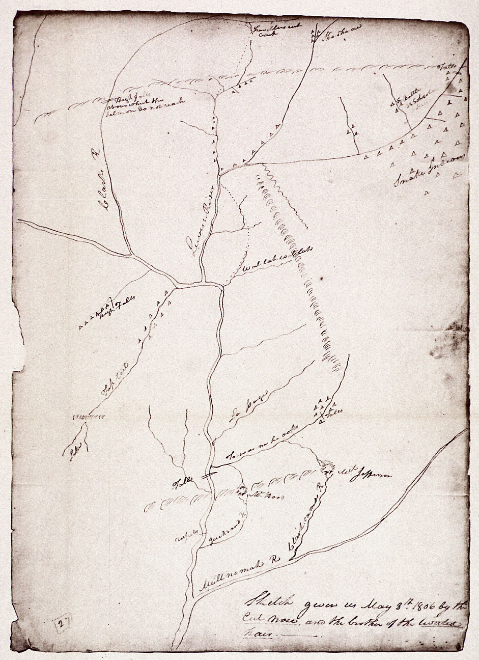
Principal Watercourses West of the Rockies
The document reproduced here is Captain William Clark’s copy of a map sketched by two Nez Perce Indians in May 1806. It shows the principal river systems west of the Rocky Mountains as they flow through what are now Oregon, Washington, and Idaho. At the center of the map are the Columbia River (unlabeled) and the Snake River (“Lewis’s River”). The Willamette River (“Multnomah R”) flows across the bottom of the map.
The acquisition of geographical knowledge was one of the primary goals of the Corps of Discovery. Prior to the 1804-1806 expedition, the area shown here was a blank space on European and American maps, a terra incognita. However, as this map proves, the area was well known to Native peoples, who regularly traveled up and down the region’s rivers and across the Rocky and Cascade mountain ranges.
According to the short note in the bottom right corner and a corresponding entry in Meriwether Lewis’s journal, this map was drawn by Neeshneparkkeook (also known as Cut Nose) and the brother of Wilewmutnin (also known as Twisted Hair), both of the Nez Perce tribe, and later copied by Clark. It is remarkably accurate, showing the correct relative location of many of the region’s major river systems, as well as a number of Indian settlements along what are now known as the Deschutes, Yakima, Wenatchee, Clearwater, Salmon, and Snake rivers. Note that the map is oriented upriver-downriver rather than north-south as in European maps.
One of the more interesting aspects of this map are the place names. They are a mix of indigenous names (Multnomah, Towahnahiooks, Wallah wallah, Tap teel), names applied by the Corps of Discovery (Lewis’s River, Clark’s River, Mt. Jefferson, Quicksand River), and one name given by an earlier English expedition (Mt. Hood). While seemingly insignificant, the renaming of major geographical features was a key step in the resettlement of the Oregon Country. It was a way for Europeans and Americans to claim the land for themselves, to make it their own.
Further Reading:
Ronda, James P. “ ‘A Chart in His Way’: Indian Cartography and the Lewis and Clark Expedition.” Great Plains Quarterly 4, 1984: 43-53.
Allen, John Logan. “Geographical Knowledge and American Images of the Louisiana Territory.” Western Historical Quarterly 2, 1971: 151-170.
Moulton, Gary, ed. The Journals of the Lewis and Clark Expedition. Volume 1, Atlas of the Lewis and Clark Expedition. Lincoln, Nebr., 1983.
Written by Cain Allen, © Oregon Historical Society, 2004.