- Catalog No. —
- OrHi 105312
- Date —
- c. 1910
- Era —
- None
- Themes —
- Geography and Places, Transportation and Communication
- Credits —
- Oregon Historical Society
- Regions —
- Portland Metropolitan
- Author —
- Unknown
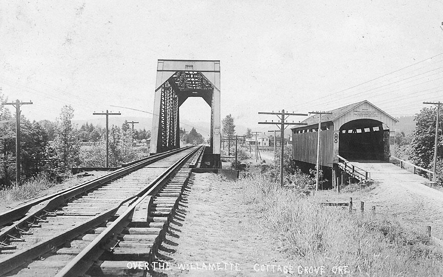
Over the Willamette River, Cottage Grove, Ore.
Two transportation routes, rail and road, appear in this photoraph taken near Cottage Grove about 1910. The bridges span the Coast Fork Willamette River, and both the railroad and the highway connect northern Oregon with the San Francisco Bay region.
The Willamette Valley transportation corridor is based on Native trails. From north to south, these trails paralleled the river on the west and east sides, avoiding marshy lands on the valley floor, and fording (crossing) tributary rivers upstream from their confluence with the Willamette . When the Oregon & California Railroad (O&C) built south from Portland in 1868, its line went closer to the river to minimize construction and operating costs. South of Eugene, where more mountainous terrain began, the paths of the old trail and the new railroad converged. The O&C built its tracks through Cottage Grove in 1871 and reached Roseburg in 1872. The railroad was completed through to San Francisco in December 1883.
By the early 1900s, both the railroad and the road were on the verge of major changes. The railroad—now the Southern Pacific Company—made major improvements along the line, such as installing new bridges able to carry heavier loads. The heavy steel truss bridge in the photo carries a construction date of 1906. At the same time, the company was engaged in long-range plans to replace this portion of their main line with a new route that greatly reduced gradients and operating problems. This line via Klamath Falls was opened in 1927, and the tracks through Cottage Grove and Roseburg became a secondary traffic route.
The highway at the right in the photograph is also a descendant of the Indian trail. Most of its traffic is very local, with horse-drawn vehicles and an occasional automobile. The covered bridge is made of wood, its timber trusses protected from the weather by a cladding of vertical boards and a shingled roof. Wooden covered bridges were once common in western Oregon, with about 450 in use between about 1905 and 1925. Standard plans for constructing covered bridges were available from the state highway department and county road departments. Oregon still has a significant number of covered bridges, most of them designated historical resources.
The state’s reliance on wood in its built environment is apparent in this photograph. The road and the railroad are both lined with wooden poles carrying communication and power wires. Railroad communications were sent by company-owned telegraph and telephone wires, and the public Western Union telegraph system used the railroad right-of-way to string its wires. The steel railroad tracks are supported by thousands of wooden crosspieces known as ties or stringers. Although concrete ties are supplanting them, wooden railroad ties are still widely used today.
Further Reading:
Smith, Dwight A., James B. Norman, and Pieter T. Dykman. Historic Highway Bridges of Oregon. Portland, Oreg., 1986
Nelson, Lee H. A Century of Oregon Covered Bridges, 1851-1952. Portland, Oreg., 1960.
Written by Richard Engeman, © Oregon Historical Society, 2005.