- Catalog No. —
- Journals 2. Thwaites : 134-137
- Date —
- June 5, 1805
- Era —
- 1792-1845 (Early Exploration, Fur Trade, Missionaries, and Settlement)
- Themes —
- Environment and Natural Resources, Exploration and Explorers
- Credits —
- Lewis & Clark Journals. Reuben Gold Thwaites. 1905.
- Regions —
- None
- Author —
- Meriwether Lewis
Decision at the Marias River
In early June 1805, the Corps of Discovery found itself at a crossroads. The explorers were determined to make their way to the source of the Missouri River, where they believed there would be an easy portage to the headwaters of the Columbia River. As they headed up the Missouri, however, they came across a fork in the river, one branch heading northwest, the other heading southwest. Geographer John Allen calls it “one of the greatest obstacles in the course of their two-year journey.”
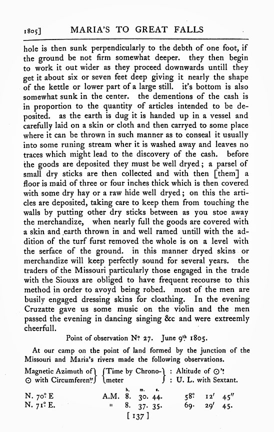
The captains worried that if the party made the wrong choice, they would waste weeks in fruitless travel and perhaps miss their chance to cross the Rockies before winter set in. Moreover, the men might be so disillusioned that the entire enterprise would collapse. This excerpt from Lewis’s journal describes part of the week-long process by which they made the crucial decision.
Lewis writes that Private Pierre Cruzatte—known for his skills as a boatman—was convinced that the north fork was the Missouri River, an assessment with which the rest of the men agreed. However, Lewis argued that the north fork was only a tributary of the Missouri, which he named Maria’s River after his cousin Maria Wood.
Lewis and Clark’s eventual decision to take the south fork was based on several pieces of evidence. First was information from Peter Fidler, a Hudson’s Bay Company surveyor who had explored the northern Rockies several years before the Lewis and Clark Expedition. While his geographical information was imprecise, it suggested that the headwaters of the Missouri were located south of the 47th parallel.
Information obtained from the Hidatsa Indians also indicated that the south fork was the correct choice. They told Lewis that the Missouri ran clear at the Great Falls. The north fork, in contrast, was a whitish color. The Hidatsa also mentioned that the Great Falls “lay a little to the South of sunset from them,” near a break in the Rockies. Lewis judged that the south fork “from its size and complexion of it’s waters” must originate in the Rockies, which still lay some distance to the west.
After scouting both routes and making a close study of the physical characteristics of the two branches, the captains decided to take the south fork. As it turned out, it was the correct decision. The Corps soon encountered the Great Falls, which was proof positive that they were still following the Missouri.
Further Reading:
Allen, John L. “Lewis and Clark on the Upper Missouri: Decision at the Marias.” Montana 21 (1971): 2-17.
Written by Cain Allen, © Oregon Historical Society, 2004.
Related Historical Records
-
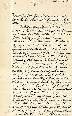
Meriwether Lewis to Thomas Jefferson, 1805
Captain Meriwether Lewis wrote this letter to President Thomas Jefferson in early April 1805 from Fort Mandan, near present-day Washburn, North Dakota. It was hand-copied and the spelling corrected …
-
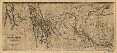
Map of Lewis and Clark's Track
This map, titled A Map of Lewis and Clark's Track across the Western Portion of North America from the Mississippi to the Pacific Ocean, published in 1814, is …