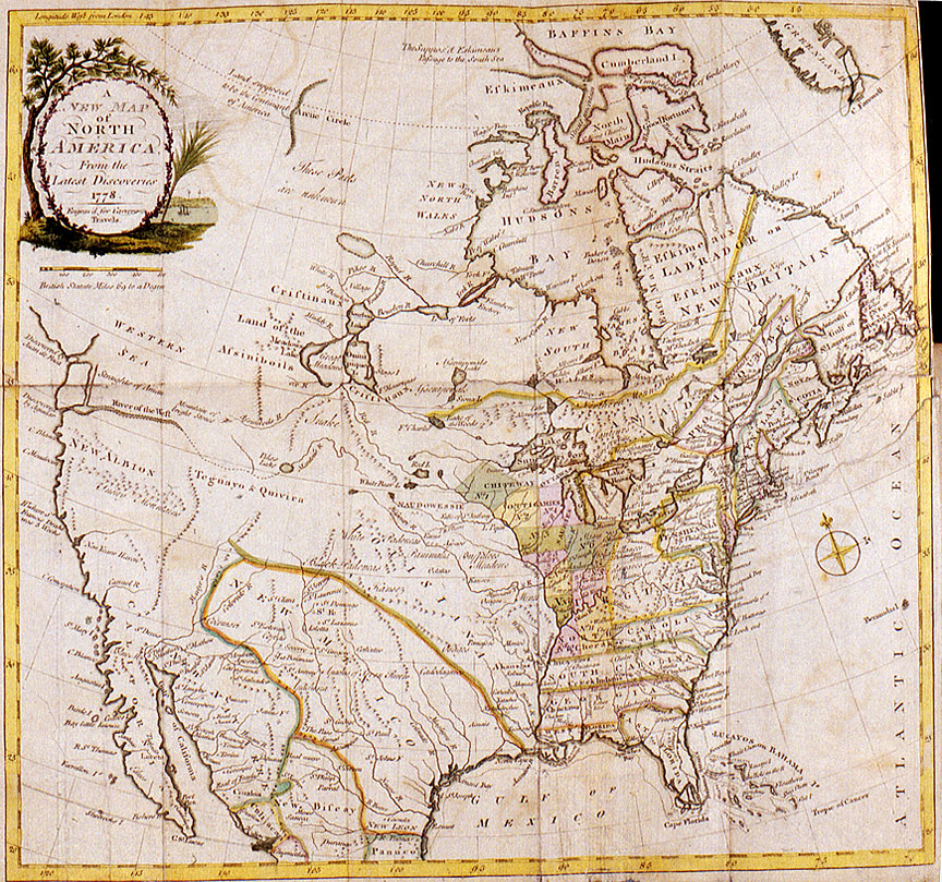
This map, entitled “A New Map of North America from the Latest Discoveries 1778,” was a centerpiece of Jonathan Carver’s Travels Through the Interior Parts of North America in the Years 1766, 1767, and 1768. Carver’s travel memoir, originally published in London, England in 1778, became an international bestseller.
Jonathan Carver, a native New Englander, was a shoemaker by profession. In 1755 at the age of 45 he joined the colonial militia to fight in the French and Indian War. Carver served six years, leaving as a captain in 1761. Determined to explore the western regions the British had recently acquired from the French, Carver taught himself map-making and surveying. In 1766 Carver was hired by Major Robert Rogers then commander of the British garrison at Michilimackinac (present-day northern Michigan), to head an exploring expedition to the Far West. Rogers’ purpose in organizing the expedition was to find an overland route to the Great River of the West (the present-day Columbia River), which Rogers referred to as the “Ouragon.” Rogers believed that the headwaters of the river “Ouragon” could be reached by following the Mississippi River to its source and then crossing the continental divide. Rogers likely gleaned this information about a great western river from Western Cree and Assiniboine peoples who had traveled across the Rocky Mountains or from French Indian and Euro American fur trappers who traded with these Natives of the northern Plains.
Although Carver’s exploring expedition to the Far West was unsuccessful on the ground, his travel memoir and the maps it contained had a profound impact on Euro American ideas about the Pacific Coast for the next several decades. The Carver maps, produced in collaboration with British cartographer Thomas Kitchin, built upon the work of earlier explorers and map-makers, as well as the experience and imagination of both Natives and newcomers. Until the overland explorations of the early 19th century conducted by the North West Company, the Lewis and Clark Expedition, and the Pacific Fur Company, Euro Americans believed in the existence a water link between the interior Mississippi-Missouri watershed and the Columbia River on the Pacific Coast.
Further Reading:
Elliot, T.C. “Origin of the Name Oregon.” Oregon Historical Quarterly 22, 1921: 91-105.
Elliot, T. C. “Jonathan Carver’s Source for the Name of Oregon.” Oregon Historical Quarterly 23, 1922: 53-69.
Byram, Scott and David G. Lewis. “Ourigan: Wealth of the Northwest Coast.” Oregon Historical Quarterly 102, 2001: 127-157.
Written by Melinda Jette, Oregon Historical Society, 2003.