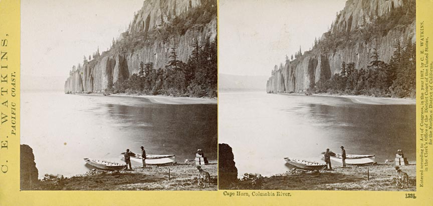
This photograph of Cape Horn on the Washington side of the Columbia River was taken by the famed photographer Carleton E. Watkins in 1867. Cape Horn was first named by Charles Wilkes of the U.S. Exploring Expedition in 1841. In the nineteenth century, however, at least five locations along the Columbia River were identified by European or American explorers and settlers with the name “Cape Horn.” Carleton Watkins took an image of “Cape Horn near Celilo,” also in 1867, which was a different geologic feature than the one currently known by the name and not the same location featured in this photograph.
The geology of Cape Horn is complex. At its base and peak are two different formations of basalt flows, a result of significant regional volcanic activity. The earliest flow was between 17 and 5.5 million years ago and the most recent circa 730,000 years ago. Between these layers is a formation of gravels deposited by glacial melting.
Watkins spent time in the Columbia River taking photographs of landmarks like these in 1867 and again from 1882-1885. His impact on the evolution of photographic methods in Oregon and across the nation was substantial. He revolutionized the art of landscape photography with his mammoth-plate prints, many of which are archived at the Oregon Historical Society Research Library.
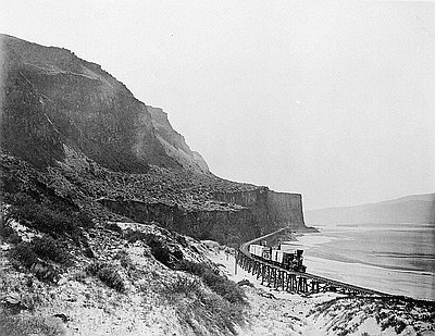
In 1867, he hauled his mammoth-plate camera, a stereoscope camera, hundreds of glass negative plates, and the equipment he needed to develop the negatives through the rugged terrain of the Gorge—before the railroads (except for short portage rail lines) and before the Columbia River Highway made the area more accessible. The attempt alone was groundbreaking; the photographical results were monumental.
His stereographs were extremely popular, benefitting from the already fashionable stereograph market which produced millions of prints throughout the nation. His mammoth images were unique in both subject and form. He produced 59 mammoth-plate photographs from that 1867 trip along the Columbia River between Vancouver, Washington and Celilo Falls.
Watkins returned to the Columbia River in 1882, 1883, and 1884-1885. The Gorge looked very different to Watkins fifteen years later and his photographic collection from those years documents the many changes he observed. A railroad had been built connecting Portland to Wallula, Washington, through the Gorge, and many of the Native American camping sites had been replaced by Oregon Railway & Navigation Company workers, mainly Chinese immigrants. The railroad company had blasted tunnels through rock faces; the salmon fishing industry had installed numerous fishwheels along the river; and the Cascades canal and locks had been built. Significantly, in this later trip, Watkins contrasted his earlier photographs of a beautiful and sometimes treacherous landscape with his later images of a land on the brink of industrialization.
Watkins’s photography became popular again in the 1970s and he has long been considered a master American photographer. In 1979, two of his albums, containing 100 photographs, sold for a combined $198,000. His contribution to the early documentation of the Oregon landscape and its people and to the art of photography is immeasurable.
Further reading:
Megan K. Freidel and Terry Toedtemeier, “Picturing Progress: Carleton Watkins’s 1867 Stereoviews of the Columbia River Gorge,” Oregon Historical Quarterly 109:3 (Fall 2008), 388-411.
Written by Amy Platt, © Oregon Historical Society, 2008.
/ 1
Artifact Title Lorem Ipsum Dolor. Courtesy Oreg. Hist. Soc. Research Lib., 48789
- Catalog No. —
- bb003876; OrHi 71682
- Date —
- Era —
- 1846-1880 (Treaties, Civil War, and Immigration)
- Themes —
- Arts
- Credits —
- Carleton E. Watkins photographs [graphic], 1861-1885, Org. Lot 93, Oregon Historical Society Research Library
- Regions —
- Columbia River
- Author —
- Carleton E. Watkins (1829-1916), photographer