- Catalog No. —
- OrHi 103695
- Date —
- 1892
- Era —
- 1881-1920 (Industrialization and Progressive Reform)
- Themes —
- Environment and Natural Resources, Trade, Business, Industry, and the Economy
- Credits —
- U.S. Commission of Fish and Fisheries
- Regions —
- Columbia River
- Author —
- Marshall McDonald, Commissioner
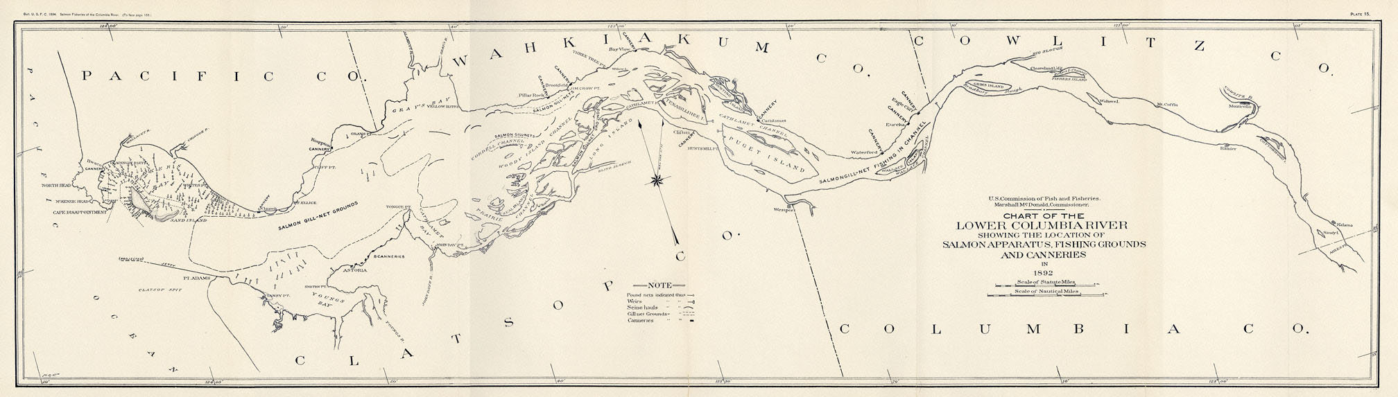
Chart of the Lower Columbia River
This map was published in an 1894 report by the U.S. Commission of Fish and Fisheries. It shows the distribution of canneries and fishing gear by type in the lower Columbia River in 1892.
One of the most striking aspects of this map is the highly clustered distribution of pound nets in Baker Bay. Pound nets, often referred to as fish traps on the Columbia River, were stationary fishing apparatuses built in shallow waters. They had a long lead that directed migrating fish into a trap made out of netting. In 1892, when this map was made, there were 378 pound nets, more than twice as many as there had been just three years earlier.
Gillnetting grounds were more evenly distributed throughout the river. While the most productive gillnetting grounds were at the mouth of the Columbia, gillnetting was practiced as far up as The Dalles-Celilo area. On the map reproduced above, gillnetting grounds can be seen near Astoria, near Brookfield, and just upriver of Puget Island.
There are a handful of seining sites shown on the map, including two near Chinook, Washington. Like gillnetting, seining was practiced in multiple places throughout the river, though the most productive grounds were in Baker Bay. Not shown on this map are fishwheels and dipnetting sites, which were not present on the lower river. Fishwheels and dipnets were used primarily in the Columbia Gorge at the Cascades and in The Dalles-Celilo area.
When this map was made there were twenty-four canneries operating on the Columbia River. Eleven of these were located at the mouth of the river, most in Astoria. Ten were located between Astoria and Portland, one was located in Portland, and two were in The Dalles-Celilo area. Canneries on the Columbia were initially established upriver of Astoria, as it was thought at first that the best fishing grounds needed to be at least twenty miles from the mouth of the river. By the time this map was made, most canneries were located close to the mouth of the river.
In 1892 the commercial fishery harvested 2.5 million salmon, including over 1 million sockeye, 916,833 chinook, 464,926 steelhead, and 63,505 coho. Gillnets accounted for nearly half of the harvest. Poundnets were the second most productive type of gear, followed by fishwheels, seines, and dipnets. The great majority of fish were canned, though some were sold fresh or salted.
Further Reading:
Cunningham, Glenn. "Oregon's First Salmon Canner, 'Captain' John West." Oregon Historical Quarterly 54 (1953): 240-248.
Smith, Courtland L. Salmon Fishers of the Columbia. Corvallis: Oregon State University Press, 1979.
Taylor, Joseph E. III. Making Salmon: An Environmental History of the Northwest Fisheries Crisis. Seattle, Wash., 1999.
Written by Cain Allen, © Oregon History Society, 2006.
Related Historical Records
-
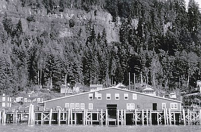
Eagle Cliff Cannery
This photograph shows the Eagle Cliff Cannery, located on the Washington side of the Columbia River about fifty miles upriver from Astoria. During the winter of 1866-1867, brothers …
-
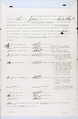
Contract between Seid Chuck & Seufert Bros.
This document is a contract between the Seufert Brothers Company, which ran a salmon and fruit cannery in The Dalles, and Seid Chuck, a Chinese labor contractor. It is dated …
-
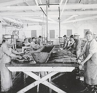
Chinese Cannery Workers near Astoria, Oregon
This stereographic image, printed by the Keystone View Company, has this description of the fish-cleaning process written on the back: “One [person] does nothing but cut off heads, tails, …