- Catalog No. —
- Gi 6921
- Date —
- circa 1922
- Era —
- 1921-1949 (Great Depression and World War II)
- Themes —
- Geography and Places, Trade, Business, Industry, and the Economy, Transportation and Communication
- Credits —
- Oregon Historical Society
- Regions —
- Portland Metropolitan
- Author —
- Benjamin A. Gifford
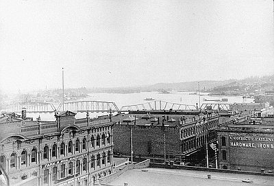
Portland Waterfront, West Side, c. 1922
This photograph of Portland’s west side waterfront was taken from one of the towers of the Hawthorne Bridge in about 1922.
Portland’s origin as a port city is apparent in this view, which shows the accumulation of buildings and structures related to river commerce after more than seventy years of development. The first warehouses, such as those of Couch & Company in 1849, were located north (to the right) of this image. A complex of docks, warehouses, lumber and flour mills, grain elevators, shipyards, and railroad tracks and roads grew haphazardly along both banks of the Willamette River. Early plans for a public levee on the west shore were thwarted by court decisions in 1861 and 1862. Public access was maintained at some points where platted streets extended to the shore, but for the most part the riverfront was privately controlled. By the 1920s, the downtown waterfront was in no position to accommodate large ocean-going general cargo vessels. The public Portland Docks Commission was formed in 1910 to address this issue, and resulted in the building of public terminals north of the congested downtown area.
The downtown waterfront of the early 1920s was still functioning but in decline. The small warehouses along Front Avenue with docks on the river side now received and shipped goods by auto truck. The river side held crumbling pilings, a few houseboats, barges, and sewer outfalls. The city embarked on a campaign to transform the waterfront through acquiring and demolishing the existing buildings and wharves and constructing a concrete seawall and sewage interceptor system. This was accomplished between 1923 and 1929, creating a widened Front Avenue and a formidable bulkhead stretching from the Burnside Bridge south beyond the Hawthorne Bridge, and eliminating all commercial activity along that section of the river bank.
The vernacular buildings and structures along Portland’s riverfront were similar to those in many other Oregon communities that once relied on rivers and the sea as commercial arteries. These ranged from Astoria, where the entire commercial district as well as docks and fish canneries were built on and over the Columbia River, to Newport and North Bend, served by both river and sea-going vessels, to riverboat towns like Coquille and The Dalles.
Further Reading:
MacColl, E. Kimbark and Harry H. Stein. Merchants, Money and Power: the Portland Establishment, 1843-1913. Portland, Oreg., 1988.
Written by Richard Engeman, © Oregon Historical Society, 2005.
Related Historical Records
-
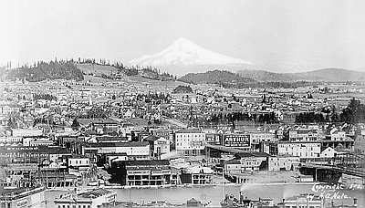
East Portland Waterfront, 1898
Here, Mt. Hood rises behind the East Portland waterfront in 1898. A barge and a steamship can be seen in the photo at lower right. The double-decker docks …
-
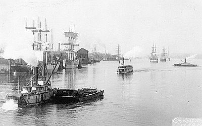
Portland Harbor, 1899
This 1899 photograph shows steam-powered sternwheelers and sailing ships in Portland’s Willamette River harbor. The photograph, which was also made into a postcard, was taken by Herbert A. …
-
Morrison Street Bridge, 1889
The Morrison Street Bridge, built in 1887, served as the first bridge to connect the east and west banks of the Willamette River. The new connection spurred explosive …